GREAT LAKES MUD
  • Home
  • Pollution
    • Dioxins
    • Heavy Metals
    • NAPL
    • Oil and Grease
    • PAHs
    • PCBs
    • TBT
    • TPH
  • Partnership
    • Great Lakes Legacy Act
    • Cost-Sharing
  • Cleanup Process
    • Project Stages
    • Dredging
    • Dry Excavation
    • Caps and Covers
    • Habitat Restoration
  • Community Revitalization
    • Ashtabula
    • Buffalo
    • Duluth
    • Muskegon
    • Sheboygan
  • Waterbody
    • Indiana >
      • East Branch - Grand Calumet River AOC
      • East Branch Phase II - Grand Calumet River AOC
      • East Chicago Waterways - Grand Calumet River AOC
      • Indiana Harbor Canal TSCA - Grand Calumet River AOC
      • Lake George Canal Middle & East - Grand Calumet River AOC
      • Roxana Marsh - Grand Calumet River AOC
      • Stateline - Grand Calumet River AOC
      • West Branch - Grand Calumet River AOC
    • Michigan >
      • Black Lagoon - Detroit River AOC
      • Centennial Park - Detroit River AOC
      • Division Street Outfall - Muskegon Lake AOC
      • Former MGP Site - St. Marys River AOC
      • Lower Rouge River Old Channel - Rouge River AOC
      • River Raisin - River Raisin AOC
      • Riverwalk - Detroit River AOC
      • Ruddiman Creek - Muskegon Lake AOC
      • Ryerson Creek Outfall - Muskegon Lake AOC
      • Tannery Bay - St. Marys River AOC
      • Torch Lake - Torch Lake AOC
      • Upper Trenton Channel - Detroit River AOC
      • Zephyr Site - Muskegon Lake AOC
    • Minnesota >
      • Azcon/DSPA Slip - St. Louis River AOC
      • Minnesota Slip - St. Louis River AOC
      • Munger Landing - St. Louis River AOC
      • Scanlon Reservoir - St. Louis River AOC
      • Slip 3 and Slip C - St. Louis River AOC
      • SLR Interlake/Duluth Tar - St. Louis River AOC
      • Spirit Lake Site - St. Louis River AOC
      • Thomson Reservoir - St. Louis River AOC
    • New York >
      • Buffalo River - Buffalo River AOC
    • Ohio >
      • Ashtabula River - Ashtabula River AOC
      • Cuyahoga River Old Channel - Cuyahoga River AOC
      • Gorge Dam - Cuyahoga River AOC
      • Jack's Marine North Slip - Ashtabula River AOC
      • Ottawa River - Maumee AOC
      • Otter Creek - Maumee AOC
    • Wisconsin >
      • Greater Milwaukee Estuary - Milwaukee Estuary AOC
      • Hog Island Inlet - St. Louis River AOC
      • Howards Bay - St. Louis River AOC
      • Kinnickinnic River - Milwaukee Estuary AOC
      • Lincoln Park - Milwaukee Estuary AOC
      • Sheboygan River - Sheboygan River AOC
      • Tyco - Menominee River AOC
    • More coming soon...
  • Education
    • Grade School Curriculum
    • High School Curriculum
    • More Resources >
      • Indiana
      • Michigan
      • Minnesota
      • Ohio
      • Wisconsin
  • Contact

Cuyahoga River Old Channel

Cuyahoga River​ Area of Concern

Site History

The lower Cuyahoga River has been modified several times over the last 200 years. Today, it empties into Lake Erie through the navigation channel west of Downtown Cleveland. A mile-long extension, called the Old River Channel, was built in 1827 and branches off the main channel before it reaches the lake. By the 1900s, the Cuyahoga River became known as one of the most polluted rivers in the country. Oil slicks on the river caught fire several times, the first occurring in 1868. The infamous 1969 fire caught the attention of Time magazine, resulting in a scathing piece on the state of river. The article incited a national movement to address water pollution, giving rise to the Clean Water Act and the Great Lakes Water Quality Agreement.
​
​Despite progress, contaminants persist in the sediment of the Old River Channel. Through its history, part of the channel was used for industrial waste disposal by a printing plant and a battery factory. In concert with ongoing restoration efforts throughout the Cuyahoga River Area of Concern, remediation could restore beneficial use of the site for the communities of Northeast Ohio.
Picture
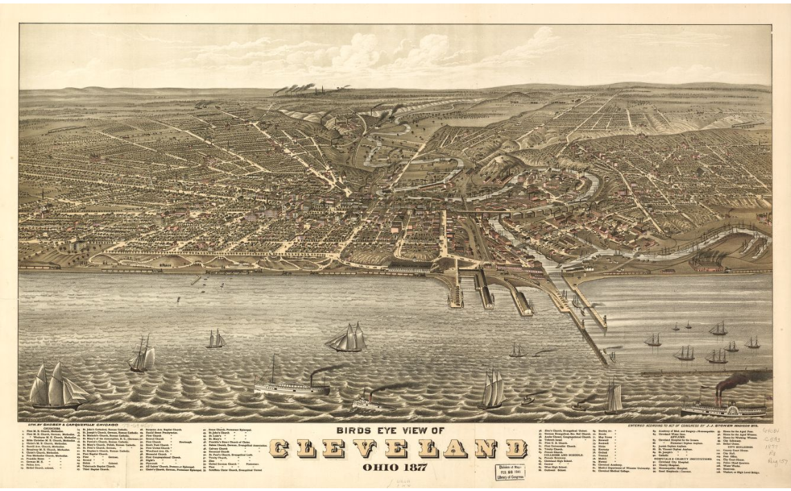
Cleveland as it appeared in 1877: The Old River Channel, which was built in 1827, is visible at the far right. (Photo Credit: U.S. Library of Congress)

Location

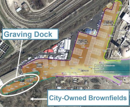
The former graving dock at the westernmost end of the Cuyahoga River Old Channel (CROC) has the highest concentrations of contaminants. To the north and the east lie the Olde River Yacht Club and the Channel Park Marina. Along the southern banks of the Old Channel, there is a privately-owned shipyard and a number of city-owned brownfields. An investigation through Ohio EPA’s Voluntary Action Program found that the sources of pollution in these brownfields are controlled and recontamination is not a concern. ​
The Old River Channel branches off the main navigation channel and lies within the Cuyahoga River Area of Concern. The marker on this map shows the location of the graving dock site.
Picture
Legacy sediments containing high concentrations of contaminants have settled in waters of the Old River Channel, and are particularly high at the old graving dock site (Photo Credit: Port of Cleveland).
Picture
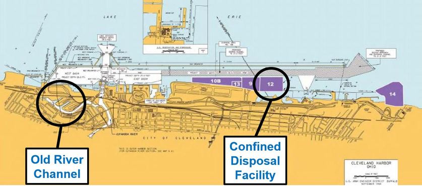
The contaminated sediment will be dredged and transported to an off-site disposal facility owned by the Port of Cleveland (Photo Credit: Port of Cleveland).
Picture
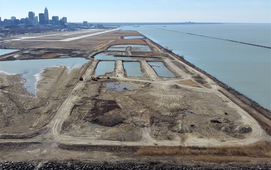
The proposed plan is to transport the contaminated sediment by barge to the confined disposal facility (CDF). (Photo Credit: U. S. Army Corps of Engineers)
Picture
This map shows the areas where contaminated sediment will be remediated.

Schedule

Cleanup Process

The multi-phase dredging project is currently being designed.
  • Phase 1: Confined Disposal Facility (CDF) Berm Construction: Spring 2025
  • Phase 2: Federal Navigation Channel Dredging: 2025-2026
  • Phase 3: CROC Shoreline Dredging: 2026-2027  ​
​Sediment to be remediated: ~100,000 cubic yards
Contaminants: PAHs, PCBs, metals, oil & grease 
Method: Dredging
Partners:  Northeast Ohio Regional Sewer District, Port of Cleveland
Cost: $23.1 million (Phases 1 & 2)

Short-term Disruptions

Sediment remediation is like a construction project on the water. It can involve large equipment, bright lights, and noise. Many projects even continue into the night and on weekends to speed up the process. Remediation can feel inconvenient, but a bit of patience results in a big payoff. 

​Public Impacts:
  • Phase 1: Minimal impact. Construction activities will be at the CDF.
  • Phase 2: Increased barge traffic in Federal Navigation Channel.
  • Phase 3: Dredging will be conducted outside of boating season.

Long-term Benefits

  • A remedial project in the Old River Channel would contribute to the efforts to restore the Cuyahoga River Area of Concern, which begins at the Gorge Dam reservoir in Cuyahoga Falls and ends along the shores of Lake Erie. 
  • Sediment remediation would prevent contamination from entering the food chain. Contaminants have negative impacts on the health of the ecosystem and contribute to fish consumption advisories on fish caught in the Cuyahoga River and the Great Lakes.
  • Restoration improves habitat for fish and wildlife species, allowing local populations to increase and thrive.​
  • ​To learn more about the significant benefits enjoyed by communities in Great Lakes Areas of Concern after a cleanup, watch the Great Lakes Legacy Act video.
Picture
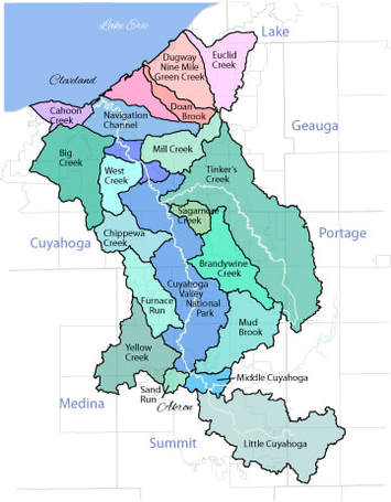
The Cuyahoga River Area of Concern encompasses the lower 46.5 miles of the Cuyahoga River and its tributaries (Photo Credit: City of Cuyahoga Falls).

Community Involvement

The Cuyahoga River Old Channel (CROC) may feel a bit tucked away from the everyday bustle of community life, but cleanup actions will have far-reaching impacts on the health of Lake Erie, as well as the local economy of Cleveland.  Contact U.S. EPA project manager, Kali Denis to provide input on the project, ask questions, or to coordinate the project with community events on the river.

May 15, 2024 Cuyahoga River Old Channel Public Information Meeting
  • U.S. EPA and project partners presented on the project cleanup design.
  • Public Notice

More Information

Documents and Resources
CROC May 15 2024 Public Information Meeting Slides (PDF, 25p, 5.5MB) May 2024
CROC May 2024 Fact Sheet (PDF, 2p, 2.3MB) May 2024
CROC Remedial Footprint Poster (PDF, 1p, 2.1MB) May 2024
CROC Confined Disposal Facility Poster (PDF, 1p, 3.3MB) May 2024

Stakeholders
City of Cleveland
Ohio Lake Erie Commission
Great Lakes Towing
Cuyahoga River Restoration
Friends of the Crooked River​
Cuyahoga Valley National Park
Ohio Environmental Protection Agency
Ohio Sea Grant
U. S. Environmental Protection Agency
​U.S. Army Corp of Engineers ​
IISG and GLR logos
Picture
Picture
Picture

Contact Us

Great Lakes Mud c/o Illinois-Indiana Sea Grant
Purdue University
195 Marsteller Street
West Lafayette, IN 47907-2033

​Email: [email protected]
© 2025 Illinois-Indiana Sea Grant, All Rights Reserved.
Illinois-Indiana Sea Grant strives to ensure equal access and an
​inclusive environment.
  • Home
  • Pollution
    • Dioxins
    • Heavy Metals
    • NAPL
    • Oil and Grease
    • PAHs
    • PCBs
    • TBT
    • TPH
  • Partnership
    • Great Lakes Legacy Act
    • Cost-Sharing
  • Cleanup Process
    • Project Stages
    • Dredging
    • Dry Excavation
    • Caps and Covers
    • Habitat Restoration
  • Community Revitalization
    • Ashtabula
    • Buffalo
    • Duluth
    • Muskegon
    • Sheboygan
  • Waterbody
    • Indiana >
      • East Branch - Grand Calumet River AOC
      • East Branch Phase II - Grand Calumet River AOC
      • East Chicago Waterways - Grand Calumet River AOC
      • Indiana Harbor Canal TSCA - Grand Calumet River AOC
      • Lake George Canal Middle & East - Grand Calumet River AOC
      • Roxana Marsh - Grand Calumet River AOC
      • Stateline - Grand Calumet River AOC
      • West Branch - Grand Calumet River AOC
    • Michigan >
      • Black Lagoon - Detroit River AOC
      • Centennial Park - Detroit River AOC
      • Division Street Outfall - Muskegon Lake AOC
      • Former MGP Site - St. Marys River AOC
      • Lower Rouge River Old Channel - Rouge River AOC
      • River Raisin - River Raisin AOC
      • Riverwalk - Detroit River AOC
      • Ruddiman Creek - Muskegon Lake AOC
      • Ryerson Creek Outfall - Muskegon Lake AOC
      • Tannery Bay - St. Marys River AOC
      • Torch Lake - Torch Lake AOC
      • Upper Trenton Channel - Detroit River AOC
      • Zephyr Site - Muskegon Lake AOC
    • Minnesota >
      • Azcon/DSPA Slip - St. Louis River AOC
      • Minnesota Slip - St. Louis River AOC
      • Munger Landing - St. Louis River AOC
      • Scanlon Reservoir - St. Louis River AOC
      • Slip 3 and Slip C - St. Louis River AOC
      • SLR Interlake/Duluth Tar - St. Louis River AOC
      • Spirit Lake Site - St. Louis River AOC
      • Thomson Reservoir - St. Louis River AOC
    • New York >
      • Buffalo River - Buffalo River AOC
    • Ohio >
      • Ashtabula River - Ashtabula River AOC
      • Cuyahoga River Old Channel - Cuyahoga River AOC
      • Gorge Dam - Cuyahoga River AOC
      • Jack's Marine North Slip - Ashtabula River AOC
      • Ottawa River - Maumee AOC
      • Otter Creek - Maumee AOC
    • Wisconsin >
      • Greater Milwaukee Estuary - Milwaukee Estuary AOC
      • Hog Island Inlet - St. Louis River AOC
      • Howards Bay - St. Louis River AOC
      • Kinnickinnic River - Milwaukee Estuary AOC
      • Lincoln Park - Milwaukee Estuary AOC
      • Sheboygan River - Sheboygan River AOC
      • Tyco - Menominee River AOC
    • More coming soon...
  • Education
    • Grade School Curriculum
    • High School Curriculum
    • More Resources >
      • Indiana
      • Michigan
      • Minnesota
      • Ohio
      • Wisconsin
  • Contact